Drone Altitude for Residential Communities in Prosper: Why Lower Isn’t Better
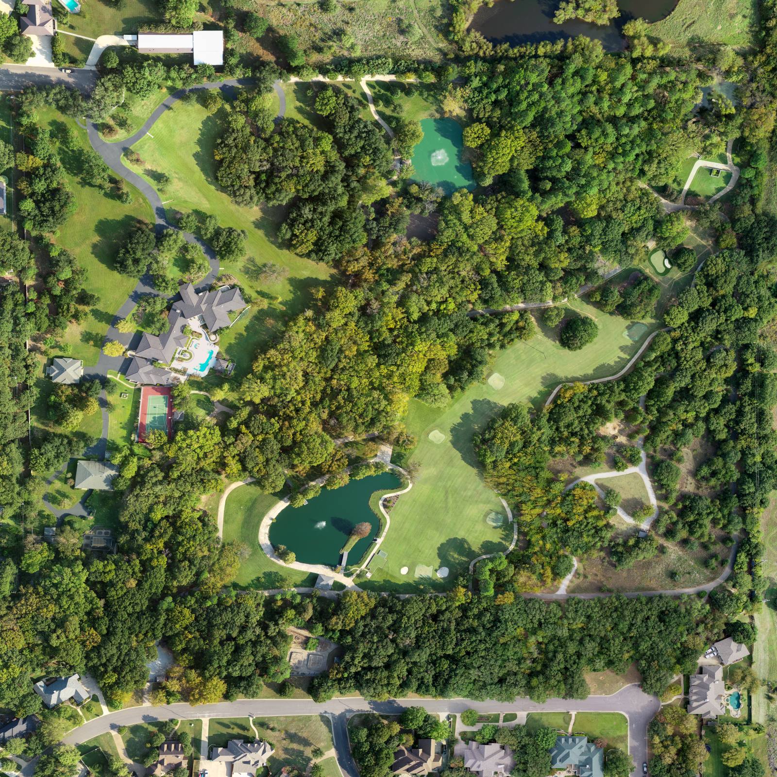
Aerial listing photos are a series of frames shot from above that show where a home sits within its neighborhood — not just the house itself, but the roads, green spaces, and nearby amenities that make it feel like part of something bigger. In Prosper, where new subdivisions stretch for miles with interconnected trails, parks, and shared amenities, how high you fly changes everything. So what does drone altitude actually do to how a home reads in a listing? It doesn’t just capture space — it tells a story about belonging.
Why flying under 200 feet hides what matters
I used to fly lower, too. In the early days, I thought getting closer meant more detail. I’d hover at 150 feet, aiming to show every shingle, every fence post. But in Prosper’s newer developments — places like The Preserve at Prosper, Stonegate, or The Retreat — flying that low made homes look like islands. Streets vanished. Walkways disappeared. The community pool, the playground, the trailhead connecting to the greenbelt — all gone. The house looked lonely. Not desirable. Just a building in a field. At 180 feet, you’re too low to see how the neighborhood connects. The road that leads to the elementary school? Hidden behind the front yard. The shared pond with the walking path? Just a blur. You’re not showing scale — you’re shrinking it.What 200 to 250 feet actually shows
I settled on 200 to 250 feet as my standard for residential communities in Prosper. That’s not arbitrary. It’s the height where the geometry of streets and lots becomes visible. At that altitude, you can see the curve of the road wrapping around the property. You see how the driveway connects to the main artery. You see the distance to the next neighbor — not as a number, but as space. And you see the landscaping that ties homes together: the mature oaks lining the boulevard, the consistent buffer of native grasses between properties. I don’t fly higher than 250 feet unless the property backs up to a major road or the neighborhood is unusually dense. In those cases, I might go to 300 feet, but only to show the relationship to the highway or the next subdivision. In most Prosper developments, 250 feet is enough to reveal the layout without losing detail. The trees still have texture. The rooflines still read clearly. The pool? Still visible. But now, so is the context that makes it worth buying into.How the light in June changes what you see
June in North Texas is relentless. The sun climbs by 6 a.m. and doesn’t soften until after 8:30 p.m. The grass is still green — if it’s been watered — but the shadows are sharp, and the contrast is brutal. If I shoot at noon, the roof becomes a white glare. The pool reflects like a mirror. The trees cast long, hard lines across the lawn. That’s why I start every shoot before 8 a.m. or wait until after 5:30 p.m. The light is softer, and the shadows stretch out. At 200 feet, that means the edge of the sidewalk, the line of the hedge, the outline of the driveway — they all become clear. You don’t just see the house. You see how the light moves across the property and into the neighborhood. I use a 24mm lens on my drone. It’s wide enough to capture the context, but not so wide that the house distorts. At 200 feet, with a 24mm lens, the perspective is natural. The street doesn’t bend. The houses don’t shrink toward the edges. It’s what the human eye sees when you stand at the end of the cul-de-sac and look down the row.What you lose when you fly too low
Flying under 200 feet doesn’t just hide streets. It hides intention. In Prosper, developers design these neighborhoods to feel connected — not just in layout, but in experience. The community garden. The shared pavilion. The walking loop that connects three streets. If your drone shot doesn’t show those, you’re selling a house, not a lifestyle. I’ve seen listings where the drone shot zooms in so tight on the front porch that you can’t tell if the house is in a cul-de-sac or on a busy corner. That’s not a mistake of equipment. It’s a mistake of thinking. People don’t buy homes because they like the color of the shutters. They buy them because they imagine their kids walking to the park, or their dog running along the trail. If the photo doesn’t show that path exists, you’re missing the point.How I sequence the shots
I never start with the front. I always begin with the aerial overview — a straight-down shot at 250 feet, centered on the property, but with enough room to include the street on all sides. That’s the anchor. Then I fly along the side of the property, keeping the same altitude, to show the backyard access to the greenbelt. Then I circle back and shoot from the corner of the neighborhood, angling in so you see the home nestled between two others, with the road curving behind it. I always shoot the same sequence: overview first, then side, then approach. That way, the buyer’s eye moves from context to detail, not the other way around. If I start with the front door, you don’t know where you are. If I start with the neighborhood, you understand why that front door matters.Frequently asked
How long does an aerial shoot take?
For a standard home in Prosper, I’m on-site for 20 to 30 minutes. That includes flying the sequence, checking for wind gusts (they’re common after 2 p.m. in June), and making sure the light is even across the frame. I don’t rush. If the shadows are too harsh, I wait. If the wind is too strong, I reschedule.Do you edit the aerial shots?
Every image I deliver is edited. I adjust contrast so the green of the grass doesn’t wash out under the June sun. I balance the exposure so the roof doesn’t blow out and the pool doesn’t turn into a white blob. I don’t add trees, roads, or houses that aren’t there. But I do make sure what’s real looks clear.Can I use the raw files?
I don’t deliver raw files unless we agree on it before the shoot. Most clients don’t need them. The edited versions are ready for MLS, websites, and print. Raw files are messy — overexposed, under-saturated, full of lens distortion. They’re not an upgrade. They’re a starting point — and I’ve already done the work.Every aerial shot I take in Prosper is meant to show you how a home fits into the place it’s built for. I fly at 200 to 250 feet because that’s where the story begins — not in the house, but in the neighborhood around it. You can find my work on the site.
Ready to book your aerial photography session?
Get a Free Quote